Give us feedback!


 See all

Our philosophy is simple. We want to encourage you to dream. BIG! Then we help you plan your trip, get the most out of it while you're traveling and help you share your experience with friends.
Join Now It's FREE
Dream Packages
Duration: 3 days
Price: $604.38
Price: $604.38
Duration: 2 days
Price: $335.27
Price: $335.27
Duration: 12 hours
Price: $211.46
Price: $211.46
Duration: 9 hours
Price: $229.00
Price: $229.00
Dreams Still To Do
Checked-Off Dreams
Dreams Still To Do
Checked-Off Dreams
Advertisement
Explore Driving Experiences
-
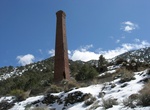
Off-road or Hike to Panamint City (Surprise Canyon), California
Panamint City is a ghost town in the Panamint Range, near Death Valley, in Inyo County, California, USA. It is also known by the official Board of Geographic Names as Panamint. Panamint was a boom town founded after silver and copper were found there in 1872. By 1874, the town had a population of about 2,000. Its main street was one mile (1.6 km) long. Panamint had it... -
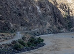
Drive along Panj River, Afghanistan–Tajikistan Border
The Panj River, also known asPyandzh RiverorPyanj River(derived from its Russian name "Пяндж"), is a tributary of the Amu Darya. The river is 1,125 km long and forms a considerable part of the Afghanistan–Tajikistan border. The river is formed by the confluence of the Pamir River and the Wakhan River near the village of Qalʿa-ye Panja (Qal`eh-ye Panjeh). From th... -
Drive Panlong Road, China
Panlong Road, a 75-km-long winding road with 600 hairpin turns, is located in NW China's Xinjiang Uyghur Autonomous Region. Tucked away in the Pamir Plateau, in the Kunlun Mountains, the winding road is also known as Pamir Plateau Sky road, Pamir´s sky road and Wacha road. At its highest point, the road is 4.269m (14,005ft) above the sea level, at the summit of ... -
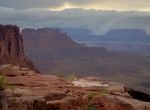
Camp at Panorama Point Campsite, The Maze, Canyonland National Park, Utah
Panorama Point has one campsite in The Maze, Canyonland National Park, Utah. It's 12 miles (2 hrs) from Hans Flat Ranger Station. -
Drive Panoramic Route, Mpumalanga, South Africa
Panorama Route is best known for its cultural heritage and its dramatic landscapes. Some of the site along the route are Blyde River Canyon, Bourke's Luck Potholes, Echo Caves and God's Window. Hazyview is a town in South Africa's Mpumalanga province which is ideally situated just a few kilometres outside the Kruger National Park. Sabie is a forestry town situated o... -
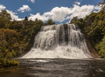
Drive or Hike to Papakorito Falls (Aniwaniwa Falls), Te Urewera National Park, New Zealand
A side trip from Lake Waikaremoana Great Walk is Aniwaniwa Falls. It's located 2 km up the Aniwaniwa Road (opposite the Visitor Centre) to Papakorito Falls. Although the forest has previously been burnt near here, the 20 metres fall is spectacular. -
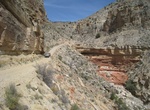
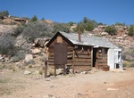
Off-road to Parashant Canyon & Copper Mountain Mine (BLM 1063 & BLM 1230), Grand Canyon-Parashant National Monument, Arizona
Travel in this area requires a 4x4 short-wheelbase high clearance vehicle. Vehicle types appropriate for this area include Jeep Rubicons, the new Ford Bronco, or UTVs (side-by-sides). UTVs must be Arizona highway legal.How do you feel about steep dropoffs right next to the road? You know, those dropoffs that go down hundreds of feet? Or how about bouncing over bedrock... -
Drive between Paris and Switzerland
Theere are several routes between Paris and Switzerland and how many days is available to get there will determine the best route. Some of the main sites along the way are: Burgundy wine region Vezelay, a UNESCO World Heritage site Ronchamp chapel Towns of Martigny, Troyes or Provins Skiing in Chamonix Explore Lake Annecy Use secondary roads, and while that area of ... -
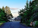
Drive Park Loop Road, Acadia National Park
The 27-mile (43 km) Park Loop Road takes you past some of the best highlights of the Acadia National Park. Offering outstanding views of the park's ocean shoreline, coastal forests, and mountain silhouettes. There are several beaches you can to relax at, a nice restaurant over a beautiful pond and other exciting attractions for the kids like Thunder Hole and Carraige ... -
Off-road to Pa's Pocket/Paws Pocket (BLM 1046/NPS 1246), Whitmore Trail, Arizona
Take BLM 1045/NPS 1245 to Pa's Pocket ranch ruins. Rough but usually appropriate for all high clearance 4x4s. The road continues and wraps around the flank of Mt. Emma to east views of the Grand Canyon. BLM 1046/NPS 1246 to Pa's Pocket ranch ruins. Rough but usually appropriate for all high clearance 4x4s. The road continues a short distance but is only appropriate f... -
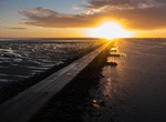
Drive Passage du Gois to Noirmoutier, France
The Passage du Gois is a 2.58-mile paved sandbar that links the town of La Barre-de-Monts to the large island of Noirmoutier off the Vendee coast of western France, fronting the Atlantic Ocean. The road floods twice each day at high tide; Crossing is permitted only during the three-hour window surrounding low tide. The town of Noirmoutier-en-Ille on the northeast end ... -
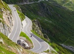
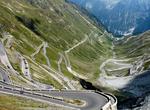
Drive Passo dello Stelvio (Stelvio Pass), Italy
The Stelvio Pass (Passo dello Stelvio), located in Italy, at 2757 m (9045 feet) is the highest paved mountain pass in the Eastern Alps, and the second highest in the Alps, slightly below the Col de l'Iseran (2770 m, 9088 feet). It is located in the Italian Alps north of Bormio in the province of Sondrio and south of Stilfs in South Tyrol, some 75 km (47 mi) from Bolza... -
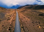
Hike or Drive Patagonian Route of Parks (La Ruta de los Parques), Chile
The Patagonian Route of Parks (La Ruta de los Parques) covers 2,800 km (1,740 miles) from the city of Puerto Montt down to Cape Horn. The trail was the idea of Tompkins Conservation, the foundation set up by US billionaire Douglas Tompkins and his wife Kristine. The land has helped create a network of 17 national parks and the new route - called the Patagonian Route o... -
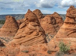
Off-road Paw Hole Road (BLM 1079), Coyote Buttes South, Arizona
To access Coyote Buttes South take Paw Hole Road (BLM 1079) near the soutern part of House Rock Valley Road. From the north take House Rock Valley Road 16.5 miles to Paw Hole Road (BLM 1079) and turn left. If coming from the south at 89A take House Rock Road 13.2 miles north to Paw Hole Road (BLM 1079). It's 2.5 miles on Paw Hole Road (BLM 1079) to the Paw Hole Trailh... -
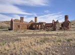
Off-road to Peake Station Telegraph Building, Oodnadatta Track, South Australia
The ruins of Peake telegraph station exist on the station today. Nearby Peake Creek was named after Edward John Peake by John McDouall Stuart in June 1859, hence Peake Station, which was acquired by Kidman Holdings in 1898. It's located at the end of a 16 kmm rough road off the Oodnadatta Track.

Price: $103.26