Give us feedback!


 See all

Our philosophy is simple. We want to encourage you to dream. BIG! Then we help you plan your trip, get the most out of it while you're traveling and help you share your experience with friends.
Join Now It's FREE
Dream Packages
Duration: 10 hours
Price: $270.00
Price: $270.00
Duration: 9 hours
Price: $229.00
Price: $229.00
Duration: 10 hours
Price: $199.57
Price: $199.57
Duration: 12 hours
Price: $211.46
Price: $211.46
Dreams Still To Do
Checked-Off Dreams
Dreams Still To Do
Checked-Off Dreams
Advertisement
Explore Driving Experiences
-
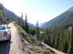
Drive Old Fall River Road, Rocky Mountain National Park
The Old Fall River Road, sometimes referred to as "The Old Road" by park staff in Rocky Mountain National Park was the first automobile road to penetrate the interior of the park. The road linked the east side of the park near Estes Park with Grand Lake on the west side. Work began in 1913 and was completed between 1918 and 1920. The narrow road was partly replaced by... -
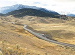
Drive Old Gardiner Road, Yellowstone National Park, Wyoming
Old Gardiner Road entrance is behind the Mammoth Hot Springs Hotel and it exits at the North Entrance to the Park in Gardiner. -
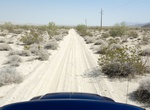
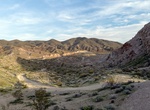
Off-road Old Kane Springs Road, Anza-Borrego, California
Old Kane Springs Road is a 4WD road connecting Hwy 78 with southern part of Ocotillo Wells. -
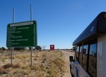
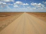
Visit Old Landsborough Highway, Queensland, Australia
Old Landsborough Highway goes between Kynuma -
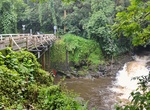
Drive Old Mamalahoa Hwy, Big Island, Hawaii
Drive the four-mile-section “Scenic Route" of Old Mamalahoa Highway on the Big Island of Hawaii. Earning the moniker, the coastline passage just outside of Hilo winds through lush rainforests, overlooks rugged Onomea Bay and crosses several century-old bridges like this one. It's about an additional 20 minutes to take this side road. -
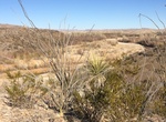
Drive Old Maverick Road, Big Bend National Park, Texas
The Old Maverick Road runs between Maverick Junction and Santa Elena Canyon. It is a 14-mile improved dirt road that passes along the Terlingua Creek badlands on the west side of the park. A number of historic sites are located near the road that you may visit as you gradually descend to the Rio Grande and Santa Elena. While usually passable for most vehicles, this r... -
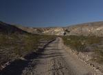
Off-road Old Ore OHV Road, Big Bend National Park, Texas
Old Ore OHV Road is a 26 miles (43km) dirt road located in Big Bend National Park between Dagger Flat Road and Rio Grande Village Road. Used in the early 1900s to transport ore from Mexican mines to the railroad station at Marathon, the Old Ore Road generally follows the route used by mule and pack trains a century ago. This road is rough and requires a sturdy vehicle... -
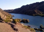
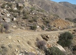
Off-road or Mountain Bike Old Ranger Station Road, Arizona
Old Ranger Station Road is 4.26 miles of backcountry road close to the Colorado River and the ruins of the Gauger’s Residence Site. When you reach the end of the road, hike the remaining 0.75 miles to the gauging station and Colorado River. Old Ranger Station Road starts on the west side of Hwy 93 south of Hoover Dam. -
See Old Route 66 & 1932 Studebaker (Petrified Forest), Petrified Forest National Park, Arizona
Petrified Forest is the only national park that protects a section of Route 66 within its boundaries. Traces of an old roadbed and weathered telephone poles mark the path of this famous US roadway. One of the Route 66 sites in the park is the old Painted Desert Inn, which was a Route 66 landmark during the 1920s and 1930s. It was converted into a museum and bookstore... -
Drive Oodnadatta Track, South Australia
The Oodnadatta Track, Australia is an unsealed 620 kilometre track between Marree and Marla via Oodnadatta in South Australia. It passes the southern lake of the Lake Eyre National Park. The Track follows a traditional aboriginal trading route, and provides travellers with some stunning semi-desert scenery. Along the Track are numerous springs feeding water from the G... -
Off-road Opal Canyon OHV Trail, Red Rock Canyon State Park, California
Red Rock Canyon State Park contains over 30 miles of 4WD back roads traversing the scenic desert terrain. A good map is needed and the visitor center gives out free rough maps showing the trails, dirt roads, 4WD roads, and serious 4WD roads. The Opal Canyon Trail is considered to be a dirt road, e.g. one of the best roads out here. It was challenging in a Subaru, but ... -
Off-road to Opal Hill Fire Agate Mine, Blythe, California
Opal Hill Fire Agate Mine is located deep into the Mule Mountains not far from Palo Verde. Opal Hill is well known for its beautiful and rare fire agate, opal eggs and quartz crystals. First drive to Coon Hollow Campground. Turn south at the Wiley's Well Road exit from Interstate Highway 10 located about 16 miles west of Blythe, California. Drive southward on Wiley's... -
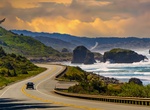
Drive Oregon Coast Highway (US Route 101), Oregon
U.S. Route 101 (US 101), is a major north–south U.S. Highway in Oregon that runs through the state along the western Oregon coastline near the Pacific Ocean. It runs from the California border, south of Brookings, to the Washington state line on the Columbia River, between Astoria, Oregon, and Megler, Washington. US 101 is designated as the Oregon Coast Highway ... -
Drive over Øresund Bridge, Sweden - Denmark
The Øresund or Öresund Bridge , is a combined twin-track railway and dual carriageway bridge-tunnel across the Øresund strait between Sweden and Denmark. The bridge runs nearly 8 km (5 miles) from the Swedish coast to the artificial island Peberholm, which lies in the middle of the strait. The remainder of the link is by tunnel from Peberholm to the... -
Off-road Oriflamme Canyon (Rodriguez Spur Truck Trail), California
Oriflamme Canyon is a steep mountain canyon, in San Diego County, California that descends from its head in the Laguna Mountains, in an arc northwestward then northeastward to join Rodriguez Canyon at the northwest end of Mason Valley, where Vallecito Wash has its source. This canyon was along the route of Native Americans across the mountains and desert between the N...


Price: $1457.59