Give us feedback!


 See all

Our philosophy is simple. We want to encourage you to dream. BIG! Then we help you plan your trip, get the most out of it while you're traveling and help you share your experience with friends.
Join Now It's FREE
Dream Packages
Duration: 14 hours
Price: $551.14
Price: $551.14
Duration: 6 hours
Price: $162.00
Price: $162.00
Duration: 4 hours
Price: $135.27
Price: $135.27
Duration: 12 hours
Price: $103.26
Price: $103.26
Dreams Still To Do
Checked-Off Dreams
Dreams Still To Do
Checked-Off Dreams
Advertisement
Explore Driving Experiences
-
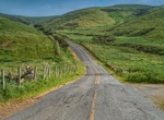
Drive Pearce Ferry Road (Dolan Spring), Arizona
If you came to the desert to see Joshua Trees, Pearce Ferry Road is the drive for you. Crossing one of the world’s finest Joshua Tree forests, Pearce Ferry Road is an unpaved backcountry road starting from US Route 93 halfway between the Hoover Dam and Kingman, Arizona. You’ll know you’ve reached Pearce Ferry when you see the picnic tables. TIPS: ... -
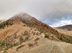
Off-road to Pearsoll Peak Lookout, Oregon
Pearsoll Peak is a mountain in the Klamath Mountains of southwestern Oregon in the United States. It is located in the northern Kalmiopsis Wilderness in southeastern Curry County and western Josephine County in the extreme southwest corner of the state, approximately 20 miles (32 km) from the Pacific Ocean and 20 miles (32 km) north of the California state l... -
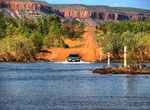
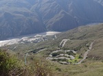
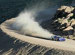
Drive Pentecost River Crossing (Gibb River Road), Western Australia
The Pentecost River is a major river crossing. The river can be 60+ metres wide and the water often flows quickly just after the end of the Wet Season . -
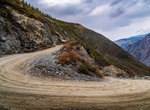
Drive Pereval Katu-Yaryk, Altai Republic, Russia
Pereval Katu-Yaryk is a high mountain pass at an elevation of 1.188m (3,897ft) above the sea level, located in Altai Republic, in Russia. The road to the summit is extreme. Only 4x4 cars. Due to the 35% gradient sections, gravel loose and the lack of protections, the road is one of the scariest drives in the world. The pass, also known as Katy-Yaryk pass, is the gate... -
Drive Pescadero Curves (Curvas de Pescadero), Chicamocha National Park, Santander, Colombia
Pescadero Curves (Curvas de Pescadero) are located within Chicamocha National Park in Santander, Colombia. They are a series of dramatic hairpin turns on a road that provides scenic views of the Chicamocha Canyon. The park, also known as a "theme park" due to its activities, offers various attractions, including a cable car that spans the canyon. The Chicamocha Cany... -
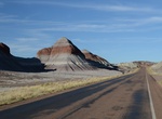
Drive Petrified Forest Road, Petrified Forest National Park, Arizona
The Petrified Forest Road in Petrified Forest National Park, Arizona is a 28-mile (45 km) park road. Off road vehicle travel is not allowed within the park, including mountain bikes. Petrified Forest National Park has a North Entrance off Interstate 40 and a South Entrance off Highway 180. Visitors may enter at one end of the park and exit at the other. Travel time t... -
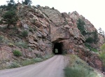
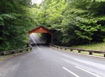
Drive Phantom Canyon Road, Colorado
Phantom Canyon Road is a scenic road that connects Cañon City and Victor. The road goes through Phantom Canyon. The road has two tunnels and three elevated bridges. It has many camp locations. It was originally the route of a railroad that connected Florence and Cripple Creek. The route contains many narrow roads and high wooden bridges. The road is unpaved. Ph... -
Off-road Phinney Canyon Road, Nevada
High-clearance first 15 miles off Hwy 95 (road is not signed), then 4WD last 3 miles. 4WD section is very rough, narrow, and has a steep technical section. Impassable in winter due to deep snow. Strozzi Ranch Road is a dead-end spur road that requires 4WD on the last 3 miles due to sections of sand. Entering the “Nevada Triangle” of Death Valley National ... -
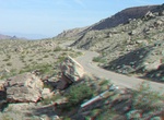
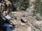
Off-road to Picacho Mine, California
Picacho, now a ghost town, was an early mining town on the Colorado River. It was named Picacho (Spanish for "big peak") after a nearby mountain of the same name. -
Drive Pierce Point Road, Point Reyes National Seashore, California
Pierce Point Road begins off Sir Francis Drake Blvd near Seahaven and ends at Point Pierce Ranch. Some of the park's roads and parking lots are closed to or do not have space for recreational vehicles (RVs) and vehicles pulling trailers. If you are traveling with a trailer or are driving an RV towing a passenger vehicle, consider unhitching at the bus/RV/trailer-only ... -
Drive or Bike Pierce Stocking Scenic Drive, Michigan
The Pierce Stocking Scenic Drive is a scenic route within Sleeping Bear Dunes National Lakeshore, in western Northern Michigan in the United States. The roadway, with its "scenic vistas and gentle curves", is located off state highway M-109 between Empire and Glen Arbor. It runs for 7.4 miles (11.9 km) through forest and dunes areas, providing access to scenic overloo... -
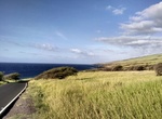
Drive Piilani Highway (Backside) to Hana, Maui, Hawaii
Take road less traveled and steer away from traffic and crowded stopsby taking the back road to Hana - as the locals do. The route starts in Kula and follow the road southwest on Piilani Highway (Hwy 31) toward Kaupo, which leads you east around the backside of Haleakala. Most of the road is desolate but along the way there is a roadside hamburger stand, a couple... -
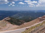
Drive Pikes Peak Highway, Colorado
The Pikes Peak Highway is a 19-mile (31 km) toll road that runs from Cascade, Colorado to the summit of Pikes Peak in El Paso County, Colorado, at an altitude of 14,115 feet (4,302 m). It is at least partially open year-round, "weather permitting",i.e.open up to the altitude where snow removal becomes excessively difficult. The highway has been home to an annual autom... -
Attend Pikes Peak International Hill Climb, Colorado
The Pikes Peak International Hill Climb (PPIHC), also known as The Race to the Clouds, is an annual automobile and motorcycle hillclimb to the summit of Pikes Peak in Colorado. The track measures 12.42 miles (19.99 km) over 156 turns, climbing 4,720 ft (1,440 m) from the start at Mile 7 on Pikes Peak Highway, to the finish at 14,110 ft (4,300 m), on grades averaging 7... -
Off-road Pilot Rock OHV Trail, California
Pilot Rock OHV Trail is a 23.2 mile 4WD trail located above Silverwood Lake State Recreation Area, California. The main trail is easy for an high clearance 2WD, however many of the side trails require 4WD. This trail ends up close to Lake Arrowhead.
Price: $499.00