Give us feedback!


 See all

Our philosophy is simple. We want to encourage you to dream. BIG! Then we help you plan your trip, get the most out of it while you're traveling and help you share your experience with friends.
Join Now It's FREE
Dream Packages
Duration: 12 hours
Price: $211.46
Price: $211.46
Duration: 9 hours
Price: $229.00
Price: $229.00
Duration: 12 hours
Price: $103.26
Price: $103.26
Duration: 6 hours
Price: $162.00
Price: $162.00
Dreams Still To Do
Checked-Off Dreams
Dreams Still To Do
Checked-Off Dreams
Advertisement
Explore Driving Experiences
-
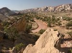
Drive Notom-Bullfrog Road, Capitol Reef National Park, Utah
The Notom-Bullfrog road intersects Utah Hwy 24 9 miles (14.4 km) east of the Capitol Reef Visitor Center and extends south to Bullfrog Marina and Glen Canyon National Recreation Area. This road is paved for the first 10 miles (16.1 km), and then becomes a well maintained dirt road. The road runs along the eastern side of the Waterpocket Fold and offers excellent scene... -
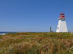
Drive Nova Scotia Lighthouse Route, Canada
The Lighthouse Route is a scenic roadway in the Canadian province of Nova Scotia that follows the province's South Shore for 339 km (211 mi) from Halifax to Yarmouth. More than 20 lighthouses can be found on this winding road along the shore. Begin your trip in Halifax and make your first stop at Peggy's Cove and walk to the lighthouse, one of the most photographed i... -
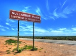
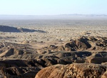
Drive Nullabour Plain, Australia
The Nullarbor Plan is part of the area of flat, almost treeless, arid or semi-arid country of southern Australia, located on the Great Australian Bight coast with the Great Victoria Desert to its north. It is the world's largest single piece of limestone, and occupies an area of about 200,000 square kilometres (77,000 sq mi). At its widest point, it stretches about 1,... -
Drive Nürburgring, Germany
The Nürburgring is a motorsports complex around the village of Nürburg, Germany. It features a Grand Prix race track built in 1984, and a much longer old North loop track which was built in the 1920s around the village and medieval castle of Nürburg in the Eifel mountains. It is located about 70 km (43 mi) south of Cologne, and 120 km (75 mi) northwest ... -
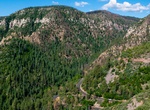
Drive Oak Creek Canyon (Route 89A), Arizona
Oak Creek Canyon is a river gorge located in northern Arizona between the cities of Flagstaff and Sedona. The canyon is often described as a smaller cousin of the Grand Canyon because of its scenic beauty. State Route 89A enters the canyon on its north end via a series of hairpin turns before traversing the bottom of the canyon for about 13 miles (21 km) until the hig... -
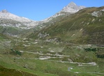
Ride or Drive Oberalp Pass, Switzerland
Oberalp Pass (el. 2044 m.) is a high mountain pass in the Swiss Alps connecting the cantons of Graubünden and Uri between Disentis and Andermatt. The public road that crosses the pass is closed in winter, but the Furka-Oberalp railway line, now part of the Matterhorn Gotthard Bahn, runs year round and provides a limited shuttle for cars in winter (reservation req... -
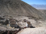
Off-road to O. B. Joyful Mine, California
O. B. Joyful Mine was first discovered in 1893. Production size when active was considered to be small. There is one known shaft. The ore mined is composed of galena, gold and pyrite with waste material consisting primarily of quartz and gypsum. -
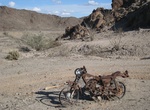
Off-Road Obregon Mines Area, California
The Obregon Mines Area is located north of Yuma, Arizona on the California side of the Colorado River and contains many abandoned mines. -
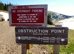
Drive to Obstruction Point, Olympic National Park, Washington
Drive to the top of Obstruction Point via dirt Obstruction Point Road in Olympic National Park. The road is closed October to July. -
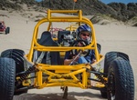
Off-road Oceano Dunes State Vehicular Recreation Area, California
Oceano Dunes State Vehicular Recreation Area is located south of Oceano. It consists of five and half miles of beach open for vehicle use and a large area of the sand dunes open for off-highway vehicle use, including quads, dirt-bikes, and four-wheel drive vehicles. It is the only state park in California where vehicles can be driven on the beach. Each ... -
Off-road Ocotillo Wells SVRA, California
Ocotillo Wells OHV Area includes over 80,000 acres of magnificent desert area open for off-road exploration and recreation. Free camping is available at numerous locations along State Route 78. The most popular of these are Main Street, Holmes Camp, County Line Road, and Pole Line Road. Each of these areas have ample access to numerous trails that provide a chall... -
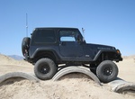
OHV Truckhaven 4X4 Training Area, Ocotillo Wells SVRA, Calif...
Truckhaven 4X4 Training Area has 22 top-of-the-line obstacles awaiting the brave (or crazy). These colorfully-named obstacles offer a variety of challenges. Stop in and hone your winching and rock-crawling skills. -
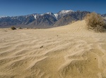
Off-road Olancha Dunes, Olancha, California
Located at the south end of the Owens Valley, Olancha Dunes OHV Recreation Area offers a diverse landscape for off-highway vehicle recreation. It is characterized by wide, rolling dunes framed between the towering Sierra Nevada and the Coso Range. -
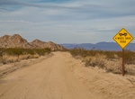
Off-road or Mountain Bike Old Dale Road & Gold Crown Road (Dale Mining District), Joshua Tree National Park, California
Old Dale Road leads to an abundance of mining history in both the Dale and Monte Negras mining districts. This 23-mile (37.3-km) Old Dale Road starts at the same point as Black Eagle Mine Road off the paved Pinto Basin Road. The first 11 miles (17.8 km), cross Pinto Basin, a flat, sandy, dry-lake bed. Leaving the basin, the road climbs a steep hill, then crosses the p... -
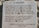
Off-road to Old Ephraim's Grave, Logan Canyon, Utah
Old Ephraim or Ol' Ephraim is a term popularized in the 19th-century American West to refer to grizzly bears. As well as describing the archetypal grizzly bear, the name has also been used in frontier folklore to refer to specific bears, most notably Old Ephraim (known as "Old Three Toes" by shepherds due to a deformity on one foot ). He was a very large grizzly bear ...

Price: $499.00