Give us feedback!


 See all

Our philosophy is simple. We want to encourage you to dream. BIG! Then we help you plan your trip, get the most out of it while you're traveling and help you share your experience with friends.
Join Now It's FREE
Dream Packages
Duration: 2 days
Price: $335.27
Price: $335.27
Duration: 3 days
Price: $559.53
Price: $559.53
Duration: 8 hours
Price: $108.64
Price: $108.64
Duration: 10 hours
Price: $199.57
Price: $199.57
Dreams Still To Do
Checked-Off Dreams
Dreams Still To Do
Checked-Off Dreams
Advertisement
Explore Driving Experiences
-
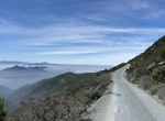
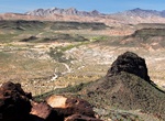
Off-road Otay Mountain Truck Trail (Otay Mountain Wilderness), San Diego, California
The Otay Mountain Truck Trail travels on the ridge tops of the San Ysidro Mountains and is frequented by the friendly U.S. Border Patrol as one can view the international border, San Diego Bay and San Ysidro Mountains. This is a popular off-road driving area. The Otay Mountain Wilderness is a U.S. Wilderness Area located in San Diego County, California, 12 miles eas... -
Off-road Otay Truck Trail, San Diego, California
The Otay Truck Trail is a shortern section near the main Otay Mountain Truck Trail. It connects the northern entance of Otay Mountain Truck Trail next to the Pio Pico RV Resort & Campground with Route 94 in Sycamore Canyon. -
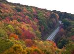
Ride Ouachita Skyway, North Carolina & Tennessee
The Cherohala Skyway (sometimes called the Overhill Skyway) is a 43-mile (69 km) National Scenic Byway that connects Tellico Plains, Tennessee, to Robbinsville, North Carolina in the southeastern United States. Its name is a portmanteau of Cherokee and Nantahala, the two national forests through which it passes. Along with multiple vistas and overlooks, the skyway pro... -
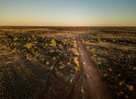
Drive Outback Highway, Australia
The Outback Highway or Outback Way is a series of roads and dirt tracks linking Laverton, Western Australia and Winton, Queensland. At 2,719 km (1,690 mi), it crosses Central Australia (colloquially known as the Outback), passing through Western Australia, the Northern Territory and Queensland. It has been proposed as a development to provide an inland route between s... -
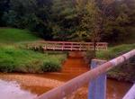
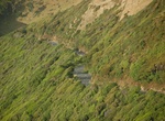
Drive Oxon Run Parkway, Washington, D.C.
The Oxon Run Parkway, is a roadway and small park in the Washington Highlands neighborhood of Washington, D.C.. 126 acres (51 ha) of important wetlands and deciduous forest is located in this urban environment. Only a single road, managed by the National Park Service, traverses the area, which is meant to demonstrate how a relatively wooded and pristine environment ca... -
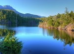
Drive Pacific Rim Highway (Hwy 4), Parksville to Tofino, British Columbia
The Pacific Rim Highway is a 150-km, two-hour drive across Vancouver Island from Parksville in the east to Tofino on the west Pacific Coast winds through ancient forest, mountain range and lakes. British Columbia Highway 4, known locally as the Alberni Highway to the east of Port Alberni and the Pacific Rim Highway to the west, is the longest east-west main vehicle ro... -
Drive Paekākāriki Hill Road, North Island, New Zealand
Paekakariki Hill Road is one of the most beautiful coastal drives in the world. Paekākāriki Hill Road runs approximately north to south from Paekākāriki to Pāuatahanui. The Paekākāriki Hill Road was built to pacify Wellington region after the Hutt Valley War of 1845-6. British Army engineers with Māori road-building gangs completed the road in November 1849, linking W... -
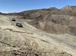
Off-road Painted Canyon Road, Mecca Hills, California
Painted Canyon Road is a 9.4 mile out and back dirt road located in Mecca Hills Wilderness Area. The road is primarily used for scenic and off road driving and and to accessPainted Canyons (Ladder Canyons), a beautiful slot canyon hike. 4WD highly recommended due to soft sand areas. -
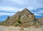
Off-road Painted Gorge (Carrizo Mountain Trail), Coyote Mountains Wilderness, California
The Painted Gorge near Ocotillo and Plaster City offers brightly colored mud hills of an ancient marine layer and volcanic flows. The leading source of color is iron. In its oxidized state, as in exposed to the air, it rusts. The BLM manages Painted Gorge and has designated it a limited use area. Be aware though, that some sections of the gorge are privately owned. -
Off-road to Pakoon Springs & Historic Tassi Ranch, Arizona
One of the popular loop drives for 4x4 vehicles is into the Grand Wash to see Pakoon Springs and Tassi Ranch. Because of its low elevation (less than 2,000 feet) this drive isn't recommended during the heat of summer. Fill your gas tank in Mesquite and take several gallons of water with you. The spring water in the monument is not safe for drinking without boiling it ... -
Off-road Palen Pass Rd, Desert Center, California
Palen Pass Road which is in an area used by Patton's Desert Training Center to train WW2 soldiers for tank warfare in North Africa. -
Drive Palms to Pines Scenic Byway (Hwy 74), California
Drive the Palms to Pines Scenic Byway (Hwy 74) from Palm Desert to the San Jacinto Mountains (Idyllwild or turn off at 371) is a great mountain road with steep inclines and switchbacks. There is a view point with a big parking lot and magificent views - on a clear day you can see the Salton Sea. -
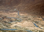
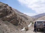
Drive Pamir Highway (M41), Central Asia
The M41, known informally and more commonly as the Pamir Highway is a road traversing the Pamir Mountains through Afghanistan, Uzbekistan, Tajikistan, and Kyrgyzstan in Central Asia. It is the only continuous route through the difficult terrain of the mountains and serves as the main supply route to Tajikistan's Gorno-Badakhshan Autonomous Region. The route has been i... -
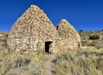
Off-road to Panaca Summit Charcoal Kilns, Nevada
The Panaca Summit Charcoal Kilns are in the high desert near Panaca Pass on Rt. 319 just east of Panaca. Two stone charcoal kilns located high in the Cedar Range of Lincoln County. They were built in the 1870s to burn wood to make charcoal for nearby silver mills. Originally there were three, but only two remain. -
Drive Pan-American Highway, Alaska to South America
The Pan-American Highway is a network of roads measuring about 47,958 kilometres (29,800 mi) in total length. Except for a 159-kilometre (99 mi) rainforest break, called the Darién Gap, the road links the mainland nations of the Americas in a connected highway system. According to Guinness World Records, the Pan-American Highway is the world's longest "motorabl...

Price: $289.36